Remember the maping of district muncipalities (or district councils)? Can we also map out the election results per muncipality. SouthAfrica has a proportional representation system. This means that the percentage of votes each party receives in a provincial or national election determines how many seats a party gets in the legislature . Advantage:More diversre range of people get to have a say in governance. Disadvantage: Lower accountabity and the agenda is set by party bosses.
Wikipedian’s can help political leaders to raise their game. I don’t want their job, but I do believe that we can make leadership more transparent. This is how Wikimedia Commons might help.
At election time, you cast a vote for a political party. Politicians performance will vary according to region and I suggest we look at Kwa Zulu Natal at Ugu Muncipality. According to the Ugu website there are 37 seats in UGU District Muncipality and four parties occuply those seats. We could represent these seats and occupants in a few ways. I prefer the arch shape, as it tells me straight away who is in the majority. It also suggests that politics is about bridging, and not always competing.
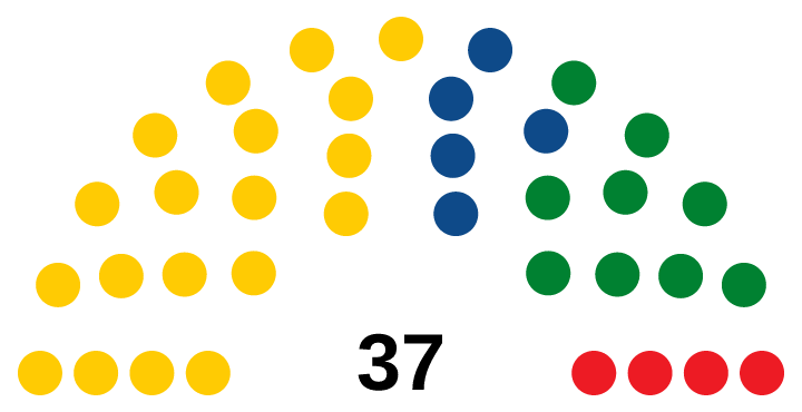
If you would like to make your own arch (or horseshoe or bridge) for your own governing structure. these are the steps you can take. My example is a South African district muncipality, but the resource supports US and Westminster legislatures.
- Go to your government website to see how many leaders/counsellors there are in that have been elected.
- Note the total number of seats and the numbers that each party holds.
- Assign a hexicidecimal colour to the parties. I used
- #ffcb03 ANC |89 963 | 51,18%
- #008131 IFP | 32 545 | 18,51%
- #0E4A89 DA | 22 990 | 13,08%
- #ED1B24 EFF|16 521 |9,40%
- Open the tool and follow the instructions to reoresent the seats.
- Press make my diagram and you have a SVG diagram to upload to the UGU District Muncipality page.
Go ahead. Visit https://parliamentdiagram.toolforge.org/ and try it out.
P.S. Sadly SA district muncipality pages on Wikipedia are not being kept up to date. So not all the muncipal election results are shown. What makes things even more complicated is that district muncipalities have local muncpalities under them. These local (and sometimes district muncipalities) shift around, due to decisions taken by the muncipal demarcation board. So there is lots of updating to do.